The Mighty and the Mite; A Log of the Trip
Home
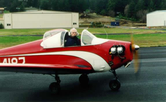
Mal Gross sits in N4187 with the
engine running.
Prologue
December 18, 1955, Houlton, Maine
The young, 22 year old pilot climbed up on the wing of N4146 for his
first flight in a Mooney M18-C. With barely 250 hours, and less than a year's
total flying experience, most of it in a Cessna 140, this pilot was about to
have an experience that he would savor for the rest of his life. The Mooney
"Mite," as it was commonly known, was a small single seat production aircraft
that looked more like a miniature fighter than a civilian aircraft, and
certainly not at all like the high wing Cessna, or Aeronca Champs, that had
comprised the only planes this young pilot had previously flown.
Sporting all of 65 hp, this retractable geared aircraft -- built of
wood and fabric -- was a beautiful low wing aircraft that you entered by
climbing up on the wing and then over the side. Since there was no electrical
system, however, the pilot first had to start the engine the old fashioned way
-- by hand. This was done by standing behind the propeller with the back of his
legs firmly placed against the leading edge of the wing to keep the plane from
moving. Then with one hand in the cockpit to handle the throttle and mag
switches, the pilot swung the propeller from the rear. He was rewarded instantly
with the roar of the four cylinder Continental engine. Then -- carefully so as
not to lose his balance in the propeller wash -- he climbed up on the wing and
over the side of the cockpit, letting himself carefully down into the seat,
before pulling the canopy closed above his head. Being 6" 2" and 185 lbs, there
was no room between his shoulders and the sides of the cockpit, and it was more
as though he were strapping the plane onto himself rather than his climbing into
the plane.
With a boyish grin and wave at the friend who had lent him the Mite, he
was then on his own -- to learn to fly a new aircraft type, to learn to handle a
retractable landing gear, and to experience flight as he had never before
experienced it. After an hour and 20 minutes he landed back at Houlton airport,
uneventfully.
But something had happened during that short flight; he had fallen in
love with the Mite. In the decades that followed he could not forget that first
love.
The entry he made in his log book summarized the experience completely,
but simply with just two words: "What Fun!"
November 30, 1995 - Day #1
Augusta, KS
40 years almost to the day have passed since my first and only flight
in a Mooney Mite. I am in Augusta, Kansas to take delivery of N4187, a 1955
model M18-C55. When N4187 was rolled out of the factory and test flown by W. W.
Taylor on March 10, 1956, there were only five more Mooney Mites to be produced
before the Kerrville, TX factory stopped manufacturing this aircraft, designed
in 1946. In total 357 Mooney Mites were made. I had just purchased one of the
last of what has to have been the Ferrari of its day.
I have flown almost 5,000 hours since that first flight, much of it in
instrument weather conditions, over mountains, and across continents, to the
furthest reaches of Alaska and to central Greenland. I have set five
internationally recognized FAI speed and altitude records for my weight class,
and have owned seven other aircraft. But the excitement and exhilaration
cruising through my blood that morning in Augusta was still the excitement of a
22 year old youth back in Houlton, Maine.
I was also apprehensive, for I was not 100% sure I was up to the task
of soloing a new aircraft type, and then flying it in early December, close to
2,000 miles -- across the Rocky Mountains -- to my home on Orcas Island, 100
miles north of Seattle. My well-meaning friends had told me that I would very
quickly feel cramped and uncomfortable, and that an hour out of Augusta I would
likely conclude I had made a mistake. They gently suggested that my
recollections of my first "affair" would fade like a puppy dog love of a
teenager as he becomes more mature.
They were wrong, but I was right to be apprehensive. Not because I was
not up to the task of soloing a new aircraft -- I was -- but because it was
winter, and I was flying a plane that was only 1/5th as heavy as my Cessna T210,
with 1/5th the horsepower, and was strictly a VFR aircraft. And as I found out,
it is much easier to fly a heavier airplane than a lighter one in windy
conditions. For all practical purposes the 5,000 hours since the first flight
counted for little. I was again an inexperienced pilot learning to fly a new and
different airplane.
But, as I eased the throttle forward for my first take-off that
morning, the memories came flooding back upon me. Not the memories of the first
Mite flight, but the memories of the sound of a four cylinder Continental 65 hp
engine that had powered my first training aircraft -- an Aeronca Champ. There
was something magical about the sound of that engine, a hoarse roar coming out
of an engine that had virtually no muffling system, and into an airplane that
had no sound insulation. At once, barely 100 feet down the Augusta runway on my
take-off run, I was transported back more than forty years to my first training
flights. Almost immediately I felt "one" with the Mite.
And so, with the confidence and the enthusiasm that only youth can
have, I again learned to fly a light airplane. Even at 8:30 in the morning,
there was a Kansas wind blowing across the runway, and as soon as N4187 had
literally jumped into the air as I pulled back on the stick, I found it bobbing
in a sea of troubled air above the runway. I had my hands full trying to tame
the Mite and getting it to go where I wanted. Weighing just 574 lbs empty, every
whiff of air current caused it to bob and go other than in a straight direction.
I was quickly reminded of a rodeo, and it took me more than just a few minutes
to get N4187 to understand that I intended to be the boss. Gradually, however,
over the course of the next 30 minutes we seemed to make peace with each other,
and I began to feel comfortable.
The landing gear took some getting used to. It is a mechanical gear
which is operated by a long handle that -- with the gear down -- runs from just
forward of the seat up toward the right rudder pedal along the fuselage. To
raise the gear the pilot reaches forward and grabs the forward end of the gear
handle, sliding a spring loaded 1 inch diameter knob down and out of a solid
ring attached to the side of the fuselage. He then moves the lever about 150
degrees toward the rear, where a similar ring is also securely fastened to the
side of the fuselage, and into which the spring loaded knob is then placed. The
movement of the lever raises, or lowers, the tricycle landing gear mechanically.
As long as the handle-knob is securely inserted into the ring the landing gear
is locked into place, either up or down. If it is not locked securely, however,
the gear will collapse on landing, or extend while flying. So it is obviously
critical for the pilot to ensure that the knob is securely in place.
The pilot, of course, must learn to raise the gear and ensure it is
locked into the retracted position while keeping his full attention outside the
aircraft. 200 feet above the runway is no place for the pilot to forget where he
is. The number one rule of flying is the same whether flying a 747 or a Mooney
Mite: "fly the airplane," then worry about everything else when you have
time.
I made three take-offs and landings at the Augusta Airport before
feeling comfortable enough to start the long trip home. I filled the 13.5 gallon
tank, filed a VFR flight plan, propped the Mite and got in. Then, in the only
concession to modern technology, I strapped onto my knee a cigarette package
size Garmin GPS 90. The antenna for this miniature navigation marvel was
fastened to the front windshield with a plastic suction cup. Two minutes later I
had acquired seven satellites and knew within 100 feet where I was. Furthermore,
the position was displayed on a rudimentary but effective moving map display,
with bearing and distance to my first refueling stop -- Woodward, OK -- clearly
displayed. This certainly beat navigating the old fashioned way - with sectional
maps that were individually twice the width as the inside of the cockpit. I had
the maps, and I did manage to use them, but only to confirm that the Garmin did,
in fact, know where we were.
Flight Planning for the Trip Home
My planning for the flight home had started two weeks before when I had
agreed to buy N4187, and sent off a check for full payment. I had been looking
for a 1955 Mite for the best part of a year -- there are only twenty-two 1955
Mites left on the FAA registry -- I wanted to take no chances of the seller, Sam
Mitchell, changing his mind, as had in fact happened earlier in the year when
another owner agreed to sell me his 55 Mite. So by the time I got to Augusta,
not only had the plane been paid for, but Sam had already found the next plane
he was going to buy.
I had stopped in Wichita three weeks earlier to see N4187, so I knew
what I was buying, but I had wanted Sam to have an annual inspection completed
before I took the plane. He had the inspection completed ten days earlier but I
had a commitment in San Francisco which precluded my picking up the Mite until
now. I felt that I needed to allow ten days for the flight back since bad
weather and flying an unknown aircraft presented potential obstacles that might
defy time schedules. That also gave me a good deal of time to do my flight
planning.
I had three concerns when I did my planning for the flight - weather,
fuel range, and high altitude performance. Obviously weather was a major
consideration given the time of the year. But an equally important factor was
that I needed to plan a route where the distance between airports was not more
than 200 nm, and airports where I could be sure of getting fuel. N4187 has a
fuel tank of only 13.5 gallons, and until I got some experience of my own, I
could not be sure exactly how much fuel the plane would use per hour. Prior
discussions with Sam had suggested slightly under 4 gallons an hour, but it is
difficult to be sure if that is accurate since each pilot tends to lean an
engine differently, and run at higher or lower rpm than others. So all I could
really be sure of, until I had personal experience, is that the fuel flow would
probably be between 4 and 5 gallons an hour. At 5 gallons an hour, I had a
theoretical range of 2 hours and 36 minutes if all of the fuel in the tank was
usable, another unknown. However, at 4 gallons an hour the range would be 3
hours and 20 minutes. Based on this, I concluded I should assume, at least until
I had more experience, that I only had a two and half hour range.
Of course the distance actually traveled is a function of both fuel
consumption and miles per hours. In theory the plane would travel 100 kts, but I
also knew I would likely have a headwind traveling west, and I used 85 kts in my
planning. This meant that 2 1/2 hours at 85 kts gave me a range of 212 nm, and
thus my estimated 200 nm maximum between fuel stops.
The third factor in the planning process was a desire to minimize the
use of high altitude airports. While the Mite has a theoretical service ceiling
of 19,000 feet, I just did not know what the actual performance would be at an
airport with, say, an altitude of 7,000 feet. For this reason I concluded that
if I were to cross the Rockies at their mid-point north/south (i.e., just north
of Denver) I should only use airports where there was a long runway - 5,000
feet.
I had mapped out three different routes taking into account altitude
and airports not more than 200 nm apart:
- The northern route across northern Montana, Great Falls, Coeur d'
Alene, ID and Spokane, ID. This is a relatively low level route, and while I
would have to get up to 10,000 feet at one point on the trip home, I would only
have to fly that high for an hour or so, and would have no airports over 4,000
feet elevation.
- The Mid route, across Cheyenne, Rock Springs, Boise, and Yakima.
This is the route with the higher altitude flying, and several airports with
elevations well over 5,000 feet. This is also the shortest and most direct
route.
- The Southern route, across Albuquerque, Salt Lake City, Boise and
Yakima. This route involved crossing the mountains at about 9,000 feet near
Albuquerque, and again near Provo, UT. Generally this route could be expected to
have better weather than the other two, although it is several hundred miles
longer.
In each instance I checked published data on availability of fuel at
each of the proposed fuel stops, both on week days and on weekends. Where
smaller airports were involved, I telephoned to confirm the information I had
because I would be in a real bind if I landed with, say, only 3 gallons left and
found that there was, in-fact, no fuel available. Also, smaller airports tend to
have shorter hours in winter months, and sometimes were not open at all in the
winter. All of this advance planning was carefully bound into a binder and was
available that gusty morning at Augusta when I finally had to decide "which
route."
In point of fact, there was no real decision to be made on which route,
because when I arrived in Augusta, a large storm system coming down from Canada
had settled in the northern plain states and the Rockies. A high pressure system
in the central plains was keeping this storm system to the north and spreading
good weather in the southern plains and southwestern states. With it, however,
were strong winds, mostly from the southwest. So the choice was clear - take the
southern route via Albuquerque, albeit with the potential of strong headwinds.
The extra distance and slower speeds would be offset by not being grounded,
perhaps for days, by bad weather.
Leg #1 Augusta, KS to Woodward, OK
Augusta, KS is on the east side of Wichita, just east of McConnell AFB.
Taking off on the first leg involved flying due south until I was south of the
Class C restricted airspace surrounding the Wichita area. The first 15 minutes
suggested that this was going to be one heck of a long trip home, for I was
headed directly into a headwind that even at less than 1,000 feet above the
ground appeared to be directly on the nose, and ground speed dropped to barely
60 kts. I had flight planned the entire flight home at 85 kts so this first
indication of the Mite's speed was not entirely reassuring. Yet one of the
advantages of my 5,000+ hours of flying over 40 years is that I have learned not
to be too quick to draw conclusions about headwinds when traveling long
distances. Strong headwinds frequently peter out as you fly long distances, and
sometimes even turn into tail winds. So while I was initially dismayed at the
slow progress of flying south to get around the Wichita airspace, I was still
making progress, and with patience would eventually get home.
Woodward, OK, is about half to Amarillo, TX, my planned overnight stop,
and just 138 nautical miles (nm) as the crow flies from Augusta. I wanted
several shorter flights to get some fuel consumption experience before trying
for 200 mile legs. The weather, aside from the winds, was perfect VFR weather.
Not a cloud in the sky, and record high temperatures for the last day of
November.
Fortunately once I got far enough south that I could turn toward the
Southwest, and Woodward, the wind was no longer directly on my nose, and the
speed picked up. One of the nice things about the Garmin GPS is that it
continually calculates ground speed and so I can quickly see what even a slight
change in direction, or altitude, does to my ground speed. I stayed low --
probably about 500 feet or perhaps a tad less -- and was careful to avoid all
towns or even farm houses. Then 1 hour and 42 minutes from takeoff I was over
the Woodward airport.
Most of the airports which I used on the trip home were near smaller
towns, and did not have a control tower. That meant that it was up to me to
overfly the airport, look at the wind sock from the air and decide which runway
to use, unless, of course, there were other planes in the pattern at the time,
in which case I joined the pattern. There was no one in the pattern at Woodward,
and looking at the wind sock, I quickly saw why. It was standing straight "out"
but whipping from side to side indicating that it was quite gusty on the ground.
And, it was! I picked the runway most into the wind and set up my approach. As I
approached the ground N4187 started bouncing around like a wild colt not yet
tamed. Yet, at the last minute, just before touching down, I managed to get the
plane lined up with the centerline of the runway and the Mite touched down just
as gently as a kitty cat.
It is funny, but until the moment we landed (the "we" being me and the
Mite - we are a team and needed each other) I had given no consideration to
needing to answer the "call of nature." But taxiing in, "nature" called and I
learned that when you have to, you can get out of the Mite fairly quickly,
albeit not in a very dignified manner. It was good that we were on the ground.
In my Cessna 210, I have a container that can be used for emergency calls of
nature, and it is no big problem. However, in the small space in the Mite I am
not exactly sure how you handle this problem. The stick is directly in front of
the seat. The seat does not move backward (or forward for that matter). You
can't turn sideways in the seat. The side of the plane prevents that. So if you
have to unzip the front of your pants I am not exactly sure how you do it
without pushing the stick forward. Unfortunately doing so would cause the plane
to go into a dive, and that is strictly a "no-no." In any case I am happy to
report that I did not have to find an answer to an in-flight "call" on the trip
home. Just as well.
It was about twelve o'clock and I pulled out my lunch bag -- for you
old timers (remember I am only 22) over age 30 that is the same thing as a lunch
pail, except that it is lighter -- and went into the FBO building where I found
a place to make a cheese sandwich using a bottle of pimento cheese spread and
some sandwich rolls. I had brought along enough makings of sandwiches to last
for four or five days because my 5,000 hours of experience had taught me that
you can seldom get more than a cup of coffee out of most airports. So maybe
being old enough to get discount fares on the airline, combined with the energy,
excitement and enthusiasm of a 22 year old has some advantages after all.
Leg #2 Woodward, OK to Amarillo, TX
My ground time was probably less than 45 minutes, even with the call of
nature and the delicious lunch (I was really hungry). Taking off in gusty
conditions is far less difficult than landing, so I wasted no time in getting
back into the air. You don't travel very fast sitting in an airport lounge.
As before, we flew low to minimize headwinds, and also to see a random
selection of the countryside. Suddenly, the ground looked quite different than
from the Cessna 210. In the 210 you can see out the front of the airplane, and
down on the pilot's side. But you cannot see down out of the copilot's side
without leaning way over, or by tipping the aircraft 45 degrees. But in the
Mite, you can see out of both sides at the same time you are looking directly
forward. That is a different perspective.
I have flown a lot in Aeronca Champs - a two-seat aircraft with one
seat behind the other. You can look down quite easily from this plane, but not
in the same way. In the Champ - a high wing aircraft - you have windows on each
side, but a solid top above you. The Champ is not really very narrow by
comparison to the Mite. In the Mite you really do feel suspended in mid air, not
by a solid airplane, but by a set of wings attached to your body. Your slightest
wish to turn seems to be answered by the Mite directly responding to your mental
request. I believe the difference in the sense of "really flying" between my
Cessna and the Mite is the same order of magnitude of difference as between the
sense of flying in a 727 and the Cessna. Few airline passengers know the sense
of flying that those who fly Cessnas feel, and likewise, those flying a Cessna
can't know the sense of flying that the Mite provides.
This leg was about the same distance as the first one, but took about
15 minutes longer. I guess the afternoon had brought slightly stronger winds, or
the winds had shifted so they were more on the nose. Also, as we approached
Amarillo we detoured around the city on the south; Tradewind airport is on the
west side of town. That may have added 5 or 10 minutes to the direct flight.
It was obvious as I got closer to Amarillo that I would still have two
or three good hours of daylight flying if I wanted to go on, rather than
over-nighting as I had originally planned. Moriarty, NM, 206 nm "down the road"
was my next planned stop.
As I refueled the plane it occurred to me that I had not seen the
tie-down rings on the wing where you could fasten a rope to tie the plane down
at night. As soon as I had refueled I got down on my hands and knees and looked
-- and looked. I could find no tie-down ring on either wing!. That seemed too
incredible to be true. All airplanes have tie-down rings. I had Sam Mitchell's
office phone and I went in and sheepishly called and asked him where the
tie-down rings were. "There aren't any. That is the way the factory built them,"
he responded. I then asked the obvious: "How do you secure the plane at night
when you are traveling cross country." "You put it in a hangar" he answered. I
thanked him, but as I hung up I was dumbfounded. Getting hangar space while
traveling cross country is extremely "iffy." But leaving it outside in uncertain
weather is even iffier. So I now had an unexpected additional planning factor to
consider in my flight planning -- being sure I stayed overnight at an airport
that could get me into a hangar.
Leg #3 - Amarillo to Moriarty, NM
I knew I could get the Mite into a hangar in Amarillo, but what about
Moriarty? The only way to find out was to telephone ahead. I did. There was
silence at the other end of the phone when I explained the problem, and the
listener went off line to talk with someone. Back on the phone he asked how long
the Mite was. I told him I wasn't sure but that I knew the wings were about 26
feet wide. He said he thought they could handle the Mite and to come on.
I left as quickly as I could because I knew I would be fighting
daylight. Moriarty is on Mountain Time, but it was almost 3 pm by the time I got
airborne, Central Time. That meant I had actually departed Amarillo at 2 pm
Moriarty time. I figured that the sun would probably set about 4:30 at Moriarty
so that would give me about two and a half hours to fly the 206 miles from
Amarillo. In fact the flight took 2 hrs and 30 minutes, and the sun was barely
above the horizon when I landed.
The flight itself was delightful - I did stay a little higher because
the terrain was gradually climbing and higher hills started appearing on both
sides of the route and in the distance. As I passed Tucumcari, NM, and later
Santa Rosa I checked my ground speed and "time to go" against the available
daylight and decided to continue on. Had unexpectedly higher headwinds reduced
my forward speed, I would have over-nighted at either of these two airports.
Moriarty was easy to find with the aid of GPS, and the Garmin moving
map. Yet, without GPS, the almost 8,000 foot runway blended into the surrounding
desert, particularly as the sun got lower in the horizon, and I suspect I would
have had trouble finding it quickly. I landed without incident and then tried to
find Sundance Aviation, the FBO I had talked with from Amarillo. They had told
me they were at the east end of the field, but I taxied by the only hangar I
could find at the east end but there was no name on it and there was no sign of
activity. It looked deserted. There were three or four gliders tied down
outside. By this time the sun had set and it was starting to get dark. I
resorted to calling Sundance on the unicom frequency. Sure enough, Sundance
Aviation is actually a glider FBO, and "yes" it was the hangar without any sign
on it.
It was good that I got there when I did because they had about given up
on me and would have gone home in a few minutes. They said they thought they
could get me in their hangar which was stuffed full of gliders of all
descriptions. But first I had to pull the Mite from the hard surface area across
about 250 feet of relatively smooth dirt area to the hangar. I did not dare try
to taxi. There were just too many small rocks, and the landing gear on the Mite
is very small, in keeping with the Mite's size. This means that ground clearance
is at a minimum - about eight inches from the tip of the propeller when it is
turning. One of the real advantages of having such a light weight aircraft is
that it is relatively easy to move on the ground. You just pull it at the
propeller hub, and if the plane is on level and smooth ground you can do so with
only one finger. Here the ground was slightly uphill, but even then I could do
it by myself.
They got the plane in the hangar, but it was a very tight squeeze, with
only about six inches clearance when they closed the hangar door. The tail
section of the Mite was right up to a beautiful glider, with less than an inch
clearance. Still an inch is as good as a mile as long as it is maintained. So,
the first night out from Augusta, N4187 spent the night in a hangar, as
apparently it has been used to doing for most, if not all, of its forty years
life.
December 1 - Day #2
Leg #4 Moriarty, NM to Farmington NM
Moriarty is 35 miles East of Albuquerque, but you would certainly not
realize how close it is when in Moriarty. Between Moriarty (elevation 6,200
feet) and Albuquerque there is a mountain range which goes up to 12,000' at
various places. The pass in the mountains that the highway follows is about at
9,000 feet.
The beautiful weather I had enjoyed the previous day was to stay with
me until late in the afternoon. VFR, visibility 50 - 100 miles, and the winds
had died down so I was no longer being bounced about, or fighting a head-on
headwind.
I was able to get airborne about 8:30, later than I would have liked,
but I was dependent on others for a ride from the motel. This first leg of the
day was planned to take me due West over the mountain pass to Albuquerque, and
then northwest across the top of the Class C restricted airspace over
Albuquerque.
Like most Mites, N4187 has no electrical system and has to be started
by hand. It does have a battery, however, that powers a navcom radio. When this
battery gets low it is taken out of the aircraft and charged on the ground.
While I was not required to do so as long as I stayed about 9,400 feet it is
always wise to let the radar controllers know that you are there, and listening
to them. This is particularly true with the Mite because it does not have (nor
is it required to have) a radar transponder that helps the radar operator see
you. Being a wood and fabric airplane, there is little to reflect radar energy,
and so I was practically invisible (or as I like to say, stealthy).
Shortly after taking off from Moriarty I tried to contact Albuquerque
Center to tell them of my presence. No response. Then I realized that I was
getting no feedback of my voice over the headset, although I could hear the hum
of the transmitter "carrier." Normally when you transmit you can hear
yourself.
The way the system works is that my headset has a boom mike attached to
it which is positioned in front of my mouth at all times, and both the mike and
the headset wires are plugged into the panel of the Mite. There is a button on
the top of the stick. To transmit, the pilot only has to push the button. So,
when I tried to call Albuquerque and could not hear myself I realized that
either my radio -- or, as it turned out -- my headset/mike was not functioning.
I tried several more times as we got closer to Albuquerque. But each time I
could hear the "carrier" portion of the transmitter, but no voice. This
presented no real problem, since I was not required to contact Albuquerque
Center.
With clear weather and no strong reason to cross the pass at the
minimum altitude I climbed to 10,500 feet. When I got through the pass just east
of Albuquerque I turned north and stayed as close to the mountains as I could
while flying around the northeast side of the city. Once I got northwest of the
city I then let down to about 1,000 feet over the desert for the direct route to
Farmington, another hundred miles to the northwest.
But that still left the question of how I was going to land at
Farmington without a radio. Farmington is an airport with a control tower and
you can't just barge in and land without permission. As I got within about 25
miles of Farmington I again tried the radio, but while I could hear the
transmission carrier, there was still no voice on it. Farmington tower could
hear the transmission carrier, too, but likewise could hear no voice. After I
had tried several times, Farmington broadcast in the blind: "Aircraft on the
Farmington tower frequency, receiving carrier but no voice."
I then had two choices. Since I could still hear Farmington tower, I
knew in what direction they were landing. By listening carefully I could
determine whether or not there were other aircraft in the pattern. I could enter
the pattern in the normally prescribed manner, and fly at pattern altitude until
the tower saw me. The tower would then likely either broadcast in the blind,
assuming that I was the aircraft which had broadcast a transmission carrier but
no voice, giving me landing permission, or would use a light gun to provide
instructions.
The second alternative would be to find another airport in the
Farmington area to land at and get fuel, and by-pass the main Farmington
airport. I looked at the map; there was another airport -- Aztec Airport --
about 15 miles away. That looked like the best bet since there were two
hard-surfaced runways, and it was likely there would be both fuel and people to
service the Mite. So I changed my course slightly and headed for Aztec. When I
got over Aztec, however, there didn't seem to be any aircraft activity on the
ground. I needed fuel and I really didn't want to waste time landing at an
airport where there was no one around, so I decided to fly to the Farmington
airport and get in the pattern as discussed above.
I did so, and I flew the pattern twice at pattern altitude, all the
time rocking the wings up and down trying to attract attention. The control
tower personnel must have had their heads in the sand because they never knew I
was there. Yet I also kept transmitting the carrier-without-voice since I knew
they could hear it, and one would think this would cause them to look up and
outside. after all that is what a control tower operator is supposed to do --
look outside and make sure one airplane doesn't hit another. But no luck. I was
reluctant to just land without permission, so I flew back to Aztec and landed
there. As I suspected, there was no one on the ground, and no fuel. Effectively
the airport was closed.
However, I was carrying a hand-held radio which was in the baggage
compartment and not accessible in flight. I got it out, fired up the Mite once
again, and headed back to the main Farmington Airport. This time my hand-held
radio was effective, and I called them just after taking off from Aztec.
"Farmington Tower. N4187. I am a very small single seat aircraft. I have just
taken off from Aztec airport where no fuel is available. I am low on fuel,
landing Farmington with information Yankee (the ATIS identification)." "Roger
4187. Do you need priority handling?" "Negative Farmington, I still have 4 to 5
gallons left."
I am not sure what the tower operator thought. For a pilot to report he
is down to 4 gallons, but is not declaring an emergency or requesting priority
treatment, certainly has to be unusual at the very least. But the tower didn't
say a thing and I landed without further difficulty. After I landed and was in
the FBO terminal, I called the tower on the phone and respectfully -- after all
they are the cops who can write a ticket against you, and there is no point in
provoking trouble -- asked what I should have done the first time I was over
their field without radio. The tower operator said that after two or three
circuits of the field, I should just have carefully landed since I knew the
runway being used and could see and listen for other aircraft. I never had the
guts to ask him why he wasn't looking out his window. No point in pushing my
luck.
I said before that the weather was beautiful. That is certainly
correct, but in one significant respect the weather was not as good as it was
the day before. While over Kansas and the Texas panhandle, the temperature had
been unseasonably warm -- I believe parts of Kansas got up to 70 degrees on the
ground. Today it is much colder, and temperature gage shows in the low 30's
while flying at higher altitudes. Now the Mite has an "idiot" knob that says
"heat" on it, but I can assure you that a 65 hp engine does not have any extra
heat to spare for the hapless pilot, and this is particularly true with the Mite
which has all four of its cylinders sticking out the side of the airplane in the
slip stream of the propeller. Heat is simply a joke. The only heat you have in
the Mite is the heat that you bring along with you when you get into the
plane.
My 5,000 hours in mostly heated, comfortable airplanes had not obscured
the memories of my early days of flying forty years ago. I had bought a pair of
insulated construction overalls, the type that construction workers put on over
their ordinary overalls in freezing temperatures. The flight from Moriarty to
Farmington was cold enough, so it was with relish that I got these overalls out
of the baggage area and put them on in the Farmington FBO's lounge. They looked
silly with the straps over my shoulder, but boy, did they feel good, and in fact
my legs did not get cold again all the way home.
The Mite attracted a good deal of attention at Farmington, for this is
a major refueling stop for both private and corporate aircraft. Sitting in the
lounge of the FBO were perhaps half a dozen corporate pilots in their sharp
uniforms, many of them young enough not to have ever seen a Mooney Mite before,
and most of them younger than the Mite itself. They all trooped out to look in
the cockpit, and then proceeded to ask me the usual questions about the plane. I
think all were a little envious.
Leg #5 Farmington, NM to Price, UT
I lost close to an hour going back and forth between the Farmington and
Aztec Airports. This became a concern because once again I had to consider the
absolute deadline of being on the ground once it got dark. It was close to noon
before I got into the air for only the second flight of the day. Going north
meant that I would have a shorter day, perhaps offset by the fact that I was
also going further west. I was also concerned because I knew from the forecast
that I was heading into weather and could expect to hit it somewhere north of
Salt Lake City. I wanted to get just as far as I could, so that if I got
weathered in overnight I would have that much less time to wait for the weather
to pass. My objective was to fly right up to the eastern-most edge of the storm,
land and overnight. Since the storm was moving to the east, I would then wait
until it had gone past me, hopefully by morning.
The 2 hours and 24 minute flight to Price, UT was spectacular. Flying
over country that Inge and I knew well from both our many flights and driving
(yes, we do have a car) was exciting, as I identified places to which we have
been. The Canyonlands area from 500 feet over the top of the surrounding plateau
gave a vista that was enhanced by the spectacular visibility. I could see Navaho
Mt. which had to be at least 100+ miles away.
The winds were relatively calm -- although still a headwind -- and I
found that I could let go of the stick and the Mite would fly in a straight and
level direction without any help from me. This is remarkable in an airplane that
is forty years old, but a testament to Sam Mitchell's careful care during the
past five years.
Price, UT was selected because it is the last airport before reaching
the Wasatch Mts. which lie north-south just east of Provo, where we intended to
cross them. The landing at this 5,600 foot elevation airport was as routine as
if it had been at sea level. I was becoming quite comfortable that the Mite
truly did have high altitude capability and could handle any airport I was
likely to ask it to go into.
Leg# 6 Price, UT to Burley, ID
The flight through the mountain pass was more difficult than I had
expected. After all, all I had to do was follow a divided highway, gaining
enough altitude to comfortably cross the mountains. Gaining altitude was the
easy part because, again, it was a CAVU day (ceiling and visibility unlimited).
I guess I was getting complacent, because there was another highway that
branched off of the one I was following, and for a couple of minutes I was not
sure of which highway I was actually following. I had my sectional maps out, of
course, but the 60 mile route from Price to Provo requires three separate maps
to cover that short distance (the Denver, Las Vegas and Salt Lake sectionals). I
had not really studied all three maps carefully enough, thinking, I guess, how
can I go wrong when all I have to do is follow a highway. And, unfolding a
single map in the confines of the Mite's cabin and finding a small section on
it, is a major accomplishment, let alone doing the same to three maps and trying
to line them up so I could really see where I was. Obviously I managed to get
back over the right highway and very shortly crossed over the pass into the
incredible beauty of the Salt Lake valley.
And beautiful it was. I was enthralled. Provo (and Salt Lake City
itself, for that matter) lie snuggled right up to the Wasatch Mts. They are at
an elevation of about 4,500 feet, but the Wasatch Mts. extend up to almost
12,000 feet within 10 miles of the heart of both cities. I had crossed the
mountains at 10,000 feet, and then turned north hugging close to the mountains.
Almost immediately, the westerly wind created an updraft as it hit against the
side of these mountains, and I climbed in level flight to 12,500, much as a
glider might. Not wanting to go higher because I didn't have oxygen for myself,
I kept the nose pointed slightly downward to offset further updraft, and in so
doing picked up speed since the Mite thought I was trying to descend. I also
realized -- thanks to the GPS -- that by turning north, the headwind I had been
having pretty much disappeared.
I had another reason for hugging the mountains. While I was flying
above the Salt Lake City Class C restricted airspace, and thus was legal, I was
also flying within 5 miles of the Salt Lake City airport. I certainly did not
want an "encounter with a 747 from outer space." In fact, as I flew north, I
could see three or four airliners on the approach to Salt Lake City.
Fortunately, the runways are north and south, which meant that the planes I saw
were also going north and south, and their pilots certainly had no desire to fly
anywhere as close to the Wasatch Mts. as I was. I felt quite comfortable with my
perch which provided almost a 360 degree view of the airspace on all sides. It
was only when I got about 15 miles north of the Salt Lake City airport and
needed to turn more to the west that I really needed to watch for other
traffic.
Once I had crossed to the west of the north-south approach path, and
outside the restricted airspace, I let down once again to about 1,000 feet over
the ground. The headwinds were not entirely gone, but more importantly, looking
ahead, I could see the start of the buildup of clouds that signaled my approach
to the storm I had been told I would meet. Obviously I could not fly into these
clouds since I could only fly "clear of clouds." The forecasts had suggested
that it might be possible to fly under the clouds, at least as far as Burley,
ID.
However, just to the east of Burley was one final hurdle: mountains
that go up to over 9,000 feet (within 10 miles of the airport). Fortunately, Rt.
84 from Ogden goes through some fairly wide valleys that allow you to fly at
about 6,000 feet and cross through these mountains. So once I had turned
northwest, north of Salt Lake City, I had followed the eastern edge of the Great
Salt Lake and then continued pretty much in a straight line until I hit Rt. 84.
At that point I followed Rt. 84, staying under the clouds that seemed to lie
right on the Utah/ Idaho border.
Once I got under the clouds, I was again fighting the necessity to land
before the sun went completely down. It was hard to tell since I was under an
overcast. But by the time I got to Burley sun was just below the horizon. What
was not hard to tell, however, was that there was a storm approaching Burley.
The winds started whipping around on the ground and when I got over Burley it
was obvious that I was going to really have my hands full in landing the Mite. I
got no response on the unicom frequency (it turned out the frequency had been
changed) and so I was truly on my own in landing (which was rough), and even
taxiing in from the runway to the FBO. In gusty winds, the secret to taxiing is
to do so slowly, using the ailerons and elevator to keep from getting a gust of
wind under either the wing or the stabilizer. By the time I got up to the FBO's
hangar (I had made prior arrangements for hangar space) it was starting to rain,
and the hangar doors were closed. I looked at my watch and it was close to 5 pm.
Fortunately the FBO was still there, and we got the Mite inside just as the
storm hit.
They told me that they were expecting snow that evening, and it
certainly looked like my good weather was a thing of the past. Well, that is why
I had allowed 10 days to get home. I could hardly complain since in the first
two days I had managed to come 2/3rds of the way.
December 2 - Day #3
Leg #7 Burley, ID to Caldwell, ID
I couldn't believe my eyes when I got up and looked out in the morning.
Not only was there no snow on the ground, but the rains had stopped and it was a
sunny day. I had expected to spend at least a day waiting for the weather to
pass, but it was obvious that it had already passed. What a good omen.
The flight to Caldwell was a short one, only 142 miles. Located just
northwest of Boise, it is an uncontrolled airport. The weather seemed especially
beautiful, but I suspect that had as much to do with the psychology of having
expected it to be a day in which I was grounded in Burley. I hardly noticed that
I still had headwinds, and in fact, it was quite a bumpy flight. This is typical
weather just after a cold front has passed through. The winds, however, were a
warning of what was yet to come.
Leg # 8 Caldwell, ID to La Grande, OR
I had not intended to go to La Grande, OR. I had intended to fly to
Pendleton, OR. But one of the things you learn early on in flying is that
sometimes things don't work out as planned and you have to be flexible.
The route to Pendleton goes across a mountain range, most of the peaks
of which were in the 5,000 - 6,000 foot range with an occasional peak going
higher. The flight had been gusty from the moment of take-off at Caldwell, and
as I approached this range of mountains, it was obvious that there was a layer
of clouds perhaps 2,000 - 3,000 feet above the mountains which I was going to
have to fly under. These mountains were on a largely north/south orientation,
and my flight path was largely a northwest direction, so I approached the
mountains from an angle, not head on. As I got closer, the winds became even
more gusty and I started wondering whether I could get across the range. In the
distance it looked like there were snow showers, or at least the clouds looked
like they might go right down to the tops of the mountains.
As I crossed the first ridge of this range, I started hitting my head
on the top of the canopy, and I began to wonder about the structural integrity
of a 40 year old wood aircraft. Could these gusts become severe enough to do
damage? Not an unreasonable question when you are being bounced around in a tiny
cockpit in an airplane that you have taken delivery of barely three days
earlier.
Once I crossed the first ridge I came upon a valley. It was smoother
over this valley, but still bumpy. Ahead was an airport (La Grande), and beyond
the airport and east of my course, perhaps 15 miles, was a wall of snow showers
that seemed to go down to the valley floor. While I was not headed in that
direction, I concluded I didn't know enough about the weather over the mountains
to Pendleton -- only 45 miles away -- to want to go further without a weather
update. I couldn't be sure that once I started over the mountains from this
valley toward Pendleton I wouldn't find impenetrable snow showers right down to
the mountain tops.
So, I landed at La Grande, OR. But not without considerable difficulty
because once I got below the tops of the mountains surrounding this valley the
winds became even more gusty. The saving grace was that one of the runways was
directly lined up into the wind, making a landing somewhat easier.
Leg #9 La Grande, OR to Pendleton, OR
Frankly when I landed I had about concluded that I should spend the
night at La Grande. The winds had bounced me around so much, and that wall of
snow showers to the northeast were suggestive of problems over the mountains.
Even before I called the FAA Flight Service Station by phone to check on weather
I confirmed that the FBO could get me into a hangar if I decided to stay. But
the FBO also told me that the forecast for the area was for snow that evening
and I might get stuck for a couple of days. Flight Service was more encouraging.
They indicated that Pendleton had ceilings of about 3,000 feet above the ground
and that their weather observer in the Pendleton tower indicated the clouds over
mountain range toward La Grande were well above the mountains, at least as far
as he could see. Based on this, I decided to try to make the 45 miles to
Pendleton, and then see where we stood with respect to weather, and going on. It
was too early in the day to stop flying, but I was certainly apprehensive.
It was bumpy. No question about it, but it was not as bumpy as it had
been just an hour before. I stayed about 1,000 feet above the terrain, and still
had about 1,000 feet of ceiling above me, with good visibilities (20+ miles).
The short flight into Pendleton was really anticlimactic.
Leg #10 Pendleton, OR to Portland (Troutdale), OR
My original flight planning had assumed that from Pendleton I would fly
north to the Yakima, WA area, refuel, and then hop over the Cascade Mts. flying
directly to Orcas Island. This is a fairly straight route, and the one we
normally take in the Cessna 210 when we refuel in Boise. Of course on those
flights we can easily fly nonstop and still have almost half our fuel left.
But as I am finding out through experience, weather over the Washington
Cascades is often best handled by climbing high and going over it -- as we can
in the 210. Often the clouds are right down on the mountains, and even the road
passes become socked in. This had been the case for most of the past week, so I
had started asking pilots at my fuel stops which route they would take to get
over the Cascades, and to Seattle. Their universal answer: "Don't go over the
Cascades this time of year - go through them via the Columbia River Gorge to
Portland, and then up Interstate 5.
So, once I got to Pendleton I had to decide: continue as originally
planned, or follow local advice. Of course, there really was no choice.
I talked again with Flight Service and they said I could expect an
overcast at about 2,000 feet over the entire Columbia River Gorge, but except
for an isolated snow shower, the visibilities were 10 miles or better. They also
gave me the weather at The Dalles which is located alongside the Columbia River,
about 50 nm east of Portland. Flight Service also indicated that there was
further bad weather coming in off the Pacific, and that, if I didn't go right
then, I might have to wait a day or two before it would again be this good.
The question, then, of course, was hangar space at Troutdale. A phone
call confirmed that there was. II had been lucky on getting hangar space on this
trip.
It was 150 miles from Pendleton to the Portland Troutdale airport. Did
I still have enough daylight left? Barely. And if headwinds slowed me down I
could always land at The Dalles. With this in mind, off we went.
Navigation on this leg was easy. We took up a northwest heading to
intercept the Columbia River, then turned west and followed it to Portland,
flying about 1,000 feet above the river. Although the sky was overcast, and
dreary, the flight was beautiful. The Columbia River Gorge truly is beautiful,
particularly when viewed from an eagle's perch 1,000 feet above the river. I
can't recall when -- if ever -- I had taken this route before, but it is
certainly one worth taking often. And now that I know about this "VFR pilots
preferred route" through the Cascades, I suspect it will become a way to get to
Orcas in bad weather.
Troutdale airport is right on the Columbia River, just a few miles west
of the mountains that form the Columbia River Gorge. It is a controlled airport,
but it is located under the Portland Class C airspace, so I could land without a
transponder. Again, I landed just before the sun went down. I had been having
full - and happy - flying days.
As with the previous night, the weather forecast for the next day was
not very good and it looked likely that I would have to stay in Portland at
least a day. Too bad, being so close to home. But I had been incredible lucky so
far. so I could hardly complain.
December 3 - Day 4
Leg # 11 Portland, OR to Orcas Island, WA (via Bellingham)
Once again the weather forecaster was wrong. The weather system moving
in off the Pacific had slowed down and was at least 12 hours behind the original
forecast. The forecaster told me that if I left promptly I would be able to stay
under the overcast at about 2,000 feet above the ground. The preferred route
basically follows interstate route 5, and can be flown at about 2,000 feet above
ground level, and miss all of the mountains to either side by 50 miles or
more.
So, off we went this early Sunday morning, full of anticipation at the
possibility of getting home. The weather was pretty much as advertised, except
for one thing. We had a tailwind! The GPS was showing a fairly consistent 130
kts ground speed for a good part of this leg. What a delightful way to end a
long trip!
Alas, alas. Never knock of wood, particularly the wood in a wood
airplane!
We made it back to Orcas Island in good time. The 190 mile flight took
barely an hour and a half. But as I approached Orcas Island I realized that it
was starting to get more than just a little bumpy. This often happens when
southwest winds hit mountains on Orcas Island (Mt. Constitution is 2,500 feet
high), creating a great deal of local turbulence. It wrecks havoc with landing
at the Eastsound airport on Orcas.
I was high on the first attempt to land, and that was a mistake. I have
since learned that the Mite likes to do things by the numbers. With the gear
retracted it does not slow down very quickly, and in this instance I tried to
enter the downwind leg for a landing to the south about two miles out, but from
2,000 feet. I never really got down to the pattern altitude of 1,000 feet until
I was on base leg, and then I had trouble slowing down so I could lower the
landing gear. I aborted that attempt to land even before turning final.
Sheepishly, I went back and entered the traffic pattern in the
conventional manner, slowed the plane down properly and got the gear down while
on downwind. The Mite was bouncing around a good deal on downwind but I still
felt I had it under control. The bouncing increased as we got lower on base leg.
Then, once I turned final, the Mite started really bouncing around almost to the
point that I wasn't sure I could control it. Then a gust raised one wing, and
even with full opposite aileron, it continued to roll. It did stop, but not
before I wondered how well the Mite would fly upside down.
I decided at that point to break off the approach. Perhaps if I had
continued, and gotten lower, the gustiness would have abated and I could have
landed. However, I was reminded of the old adage: "There are old pilots, and
there are bold pilots. But, there are no old, bold pilots." While I had been
enthusiastic about my transformation back to being a 22 year old for four days,
I decided that it was time for the "real me" to exercise the "old" pilot
caution.
We headed for the mainland - and the Bellingham airport with its 5,000
foot runways, and clean approaches with no mountains nearby to disturb the
airflow. The landing there was without incident although there was a strong wind
blowing. I managed to find hangar space to get the Mite in so that both of us
could fly another day.
Bellingham is only 14 miles from Eastsound, but it is all over water,
so having "called it a day" in Bellingham presented certain logistical problems
in terms of my getting back to Orcas Island. Once again, luck was with me. West
Isle Air, the local commuter airline, has three flights a day to Eastsound from
Bellingham. I landed about 10:30, and their next flight was a little after 11. I
was the only passenger, but I was back on Orcas Island by noon, exhausted but
both disappointed and exhilarated.
The next morning I took the 8 am West Isle Air flight back to
Bellingham, retrieved the Mite, and landed uneventfully on Orcas at 9:30 am.
The Mighty Mite was home.
Epilogue
Inge and I have always tried to give our planes nicknames. Our Cessna
210 is referred to as "Mike Golf" which derives from the call letters: N210MG.
Our Cessna 172 became known as the "damn Yankee;" its call letters were N2549Y,
and it always seemed to be in the shop for maintenance. Thus the "damn"
Yankee.
So one of the first questions we tackled after I got home: What to call
the Mite. This was settled for us when my 89-year-old Mother called and asked
how our "Mickey mouse" airplane was doing. We then hit on the name: the Mighty
Mouse. So N4187 is affectionately referred to as The Mighty Mouse around our
household. That also helps to explain the title of this travel account: "The
Mighty and the Mite."
The "mighty" being a play on the word "mite."
Mal Gross
January 17, 1996